
Why Some El Niño Hurricane Seasons Still Produce Early Atlantic Storms
El Niño and the “early storm” surprise
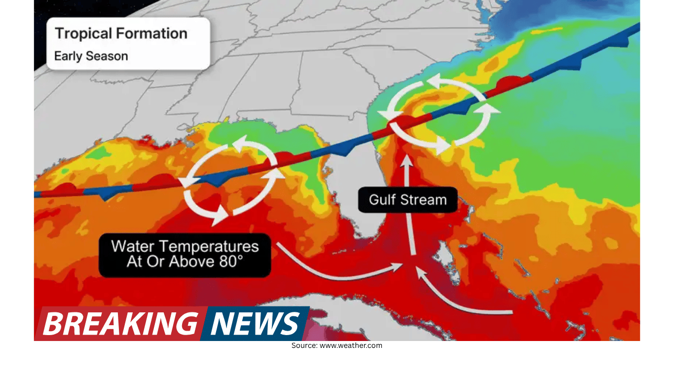
The Atlantic hurricane season has an official start date of June 1, a marker that helps emergency managers, coastal communities, and travelers shift into a more vigilant rhythm. Yet the atmosphere does not always follow the calendar. In some years, tropical or subtropical systems have developed in May, even during El Niño conditions that are otherwise associated with reduced hurricane activity.
This can feel like a contradiction: if a strong El Niño is expected to suppress Atlantic tropical development, why would any storm form early at all? The answer lies in timing and in the types of weather systems that dominate late spring. El Niño can increase wind shear over parts of the Atlantic basin, a factor that tends to disrupt developing tropical cyclones. But that wind shear does not necessarily dominate every location in the same way at every moment. There can be a brief window before the typical El Niño-related shear pattern fully asserts itself, and that window can coincide with springtime weather features that occasionally acquire tropical characteristics.
Recent examples: storms that formed around the season’s doorstep
Two recent cases illustrate how early-season systems can appear even when the broader seasonal outlook points toward fewer storms overall. These examples also show a key theme of many May systems: they often form close to land, can develop quickly, and may have limited time between formation and landfall.
Tropical Storm Arlene (2023): Arlene was active in the Gulf during the last few days of May and was classified as a tropical system on June 1. It was short-lived, lasting until June 3. The system traveled south before weakening and did not make a direct U.S. landfall.
Tropical Storm Ana (2015): Ana formed on May 8 and made landfall along the South Carolina coast on May 10 near Myrtle Beach. It was the earliest recorded tropical system to make landfall in the U.S. Ana brought winds of about 45 mph and more than 6 inches of rain. Several homes flooded, and a few water rescues took place as the storm affected South Carolina.
These storms are reminders that “early” does not necessarily mean “strong,” but it can still mean “impactful.” In Ana’s case, rainfall and flooding consequences were central. In Arlene’s case, the system’s brief lifespan and track meant it did not produce a direct U.S. landfall, but it still represented a pre-season or near-start-season tropical presence in the Gulf.
How can a storm form early during an El Niño year?
El Niño is often discussed in terms of its seasonal influence: during strong El Niño conditions, Atlantic hurricane activity is typically reduced. That expectation is tied to large-scale atmospheric patterns, including increased wind shear that can tear apart storms trying to organize. However, early-season storms often arise from different setups than the classic midsummer and early autumn “Cape Verde” style hurricanes that develop deep in the tropics.
In late spring, the ingredients and mechanisms for storm formation can look different. The path to a named storm may involve weather systems that begin as non-tropical features and only later acquire tropical characteristics when they move over warm water. In this context, it is not that El Niño “creates” early storms; rather, the usual suppressing factor—wind shear—may not yet be fully in place, leaving a narrow opportunity for development if other conditions line up.
Two common pathways for May development
Early-season storms do not all form the same way. Still, there are two broad patterns that frequently show up in late spring and can, under the right circumstances, lead to a tropical system close to the U.S. coastline.
1) A spring low-pressure system that drifts into warm water
During spring, areas of low pressure often move across the southeastern United States. This is a familiar setup for rounds of severe weather, which is typical for the season. Occasionally, however, a low-pressure system can drift southward into the Gulf of Mexico. Once over warm water, it may begin to tap into that heat and moisture.
When that happens, the system can gain tropical characteristics and transition into a tropical cyclone. These storms often form near the coast and tend to be weaker in nature. A defining feature of this pathway is the short lead time: there is often not much time between the moment a system becomes organized enough to be classified and the moment it affects land.
2) A stalled frontal boundary that lingers offshore
Another late-spring setup involves fronts that do not fully clear the Southeast coast. Instead, they can stall, leaving a boundary draped over warm waters of the Gulf or the western Atlantic. Stalled fronts can create persistent unsettled weather, and that repeated shower and thunderstorm activity can sometimes provide a developing system the time it needs to organize.
As with low-pressure-driven systems, storms that form along stalled frontal boundaries often spin up relatively close to the coastline and are frequently weaker than peak-season hurricanes. But “weaker” does not mean “harmless,” especially when rainfall becomes the primary hazard.
Why weaker early storms can still be serious
Intensity is only one measure of risk. Even relatively modest tropical storms can produce dangerous impacts, particularly heavy rainfall and flash flooding. Quick-developing systems can focus moisture over the same areas, and if a storm moves slowly, the flooding risk can rise quickly.
Early-season systems can also challenge expectations because they may not behave like the storms people associate with the peak months of August and September. Their origins may be tied to springtime fronts or migrating lows rather than long-tracked tropical waves. That difference can affect how quickly a storm organizes and how much warning time communities receive.
Early storms do not predict a busy season
It is tempting to treat an early named storm as a sign that the rest of the season will be unusually active. But the timing of the first named storm is not a reliable indicator of how many storms will occur overall. There is little correlation between when the first named storm forms and how busy the full season becomes.
History includes years in which May storms were followed by relatively quiet seasons, as well as years that started later and still became extremely active. The larger seasonal outcome depends on the broader atmospheric pattern—factors such as wind shear, ocean temperatures, and thunderstorm activity in the tropics. During super El Niño seasons, that overall activity is typically down, even if a brief early-season window allows a storm to form near the start of the season.
What to watch for as the calendar turns to June
The existence of pre-season storms is less a contradiction and more a reminder that hurricane risk is not limited to a single set of dates. The official season provides a useful framework, but spring weather systems can occasionally take on tropical traits when they reach warm water. In practical terms, that means coastal residents and anyone with plans near the Gulf Coast or the western Atlantic should stay aware of changing conditions as late spring transitions into early summer.
Because these systems can form close to land, the window between “unsettled weather” and “tropical storm” may be short. And because heavy rain can be a defining hazard, attention should not be limited to wind forecasts alone. Flooding can occur even when a storm’s winds are not extreme.
A season can be below average and still have early impacts
A below-average seasonal forecast does not eliminate the possibility of impactful weather. It simply reflects expectations about the total number of storms and overall activity based on large-scale patterns. Early storms during El Niño years underscore that the atmosphere can still produce localized exceptions—especially before the typical El Niño-related wind shear pattern fully takes hold.
In other words, a season can be projected to have fewer storms and still deliver an early tropical system that tests preparedness, brings heavy rain, or causes flooding issues. The lesson from recent May systems is not that every El Niño year will start early, but that it can happen—and that staying alert in late spring remains a sensible approach.
Jennifer Gray is a weather and climate writer who has covered major weather and climate stories for the last two decades.