
Why Flash Flooding Can Hit So Hard in Mountains, Hills and Cities
Flash floods can arrive faster than people expect
Flash flooding is one of the most sudden and dangerous weather-related threats because it can escalate from routine rainfall to life-threatening conditions in a very short period of time. What looks like an ordinary creek, drainage, or low-water crossing can become a powerful surge before many people have time to process what is happening.
Meteorologist Sara Tonks describes how dramatic the change can be, especially in mountainous settings. In her words, “A creek that is 6 inches can quickly go to 10 feet deep within an hour.” That kind of rapid rise is the defining feature of a flash flood: the water level and flow can increase so quickly that waiting to “see how it looks” can remove the chance to react safely.
While flash flooding can occur in many places, certain landscapes and local conditions make it more likely to intensify quickly. Mountains are a major hotspot, but the same basic dynamics can also affect hilly areas and communities downstream—along with cities where drainage infrastructure struggles to keep up with intense rainfall.
Mountains act like a funnel, concentrating water into valleys
One reason mountain regions are so prone to flash flooding is simple geometry. Tonks explains it this way: “When you have mountain shapes, you’ve got essentially a funnel. If there’s rain over that funnel, it all funnels down into the valley.”
This “funneling” effect matters because it concentrates runoff from a broad area into a narrower channel. Rain falling across slopes and ridgelines does not stay evenly distributed. Gravity pulls it downhill, and the surrounding terrain guides it toward creeks, streambeds, and valleys. The end result is that water from many different slopes can arrive at the same low point at roughly the same time.
That concentration is what can turn a small creek into a surging torrent. Even if rainfall seems moderate in one spot, the valley below may be receiving the combined runoff from multiple nearby slopes. In practice, this means a community or roadway in a valley can face a sudden rush of water that does not match what people just experienced where they are standing.
Terrain can also increase rainfall through orographic lifting
Mountains do more than steer water after it hits the ground. They can also help produce heavier rainfall in the first place through a process known as orographic lifting.
As Tonks describes it, “When moist air approaches that hill, it gets forced up, it condenses and then it rains out.” When air is pushed upward by terrain, it cools, moisture condenses, and precipitation can increase. This matters for flash flooding because it can raise the amount of rain falling over the same landscape that is already primed to funnel runoff into narrow drainages.
Tonks summarizes the combined risk clearly: “There’s both a geographic shape that’s funneling the water and then also the orographic lifting is helping produce more water.” In other words, the same terrain that channels runoff can also contribute to the rainfall that feeds that runoff. When those factors align, the speed and intensity of flooding can be “quite shocking,” as she puts it.
Wildfire burn scars can reduce absorption and increase debris flow risk
In some regions, mountainous flood risk is compounded by wildfire impacts. Tonks points to California as an example where burn scars can add another dangerous layer.
After a wildfire, the landscape can respond differently to rainfall. Tonks explains that “The soil in burn scars is definitely less able to absorb water very quickly.” When the ground cannot take in water efficiently, more rainfall becomes rapid surface runoff. That runoff rushes downhill faster, and it can carry debris along with it.
This is an important detail for understanding why flash flooding can be so destructive in certain areas. It is not only about the volume of water. It is also about how quickly that water moves and what it picks up as it travels. In burn-scar terrain, the combination of fast-moving runoff and debris can intensify impacts in drainages, along roads, and in communities downslope.
Real-world disasters show how quickly mountain regions can be overwhelmed
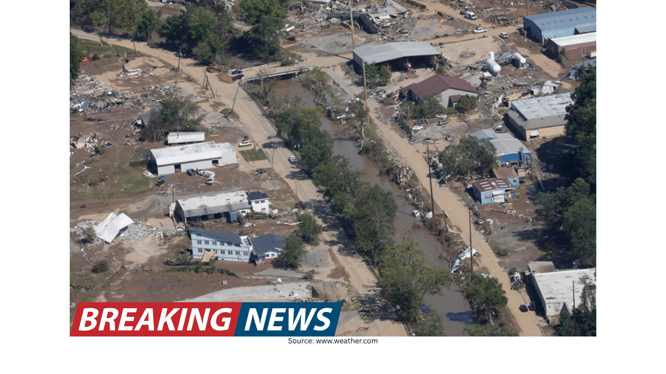
Recent disasters underscore how these ingredients can come together. Tonks points to Hurricane Helene as a prime example of how mountainous terrain can amplify flooding impacts.
In her assessment, “All those mountain regions were just funneling the water into areas that could not handle that amount of water in that short a period of time.” That statement captures the core flash-flood problem: it is not always the total rainfall alone, but the rate at which water is delivered to a particular location. When a large area drains into a narrow valley quickly, the receiving streams, culverts, and channels may be overwhelmed.
For people living in or traveling through mountain regions, this helps explain why a calm-looking creek can become dangerous with little warning. The valley may be receiving runoff from rainfall that is occurring over a wider “funnel” upstream, and the timing can be fast enough that conditions change dramatically within an hour.
Flash flooding is not limited to mountains
Although mountains are a standout hotspot, the risk does not disappear outside high elevations. Tonks notes that hilly terrain and urban areas with poor drainage can face similar dangers.
One key issue is that heavy rain upstream can funnel into communities downstream, catching people off guard. This can happen even when the downstream location is not seeing the heaviest rainfall at that moment. Water moves, and it often moves toward the same low points: creeks, channels, underpasses, and drainage systems. A neighborhood or roadway downstream can therefore face rapidly rising water even if the immediate rainfall seems less intense than expected.
In cities, the challenge can be different but just as serious. When drainage systems are limited—whether due to design constraints, capacity issues, or local conditions—intense rainfall can exceed what stormwater infrastructure can carry away quickly. The result can be fast-developing street flooding that creates hazards for drivers and pedestrians, especially where water collects in low spots.
Detection and communication challenges can delay awareness
Another factor that can make flash flooding more dangerous is that it is not always detected or communicated as quickly as people assume. Tonks highlights a technical limitation that can affect warning timelines: “The radar might not be able to accurately measure the amount of rainfall that has already fallen.”
If rainfall estimates are uncertain, it can complicate the process of assessing how much water is already in the watershed and how close creeks and channels may be to overflowing. In fast-moving situations, even small delays can matter, because flash floods can develop on short timescales.
Communication can also be harder in rugged terrain. Tonks notes that limited cell service or difficult topography can mean people may not realize the danger until it is too late. In practical terms, this can look like a situation where warnings are issued but not received, or where people cannot easily check updates as conditions change.
Once flooding starts, escape routes can disappear quickly
Flash flooding is not only dangerous because of rising water; it can also cut off the very routes people would use to reach safety. Tonks warns that “There’s a chance that your access to major roadways could already be washed out.”
She ties that concern to what was observed during Hurricane Helene: “That's one of the things we saw a lot with Hurricane Helene. All of these mountain roadways got washed out, and people were left with no way of communicating or traveling to the outside region.”
This is a critical point for anyone in mountainous or hilly areas. Roads often follow valleys and river corridors because those routes are the most practical to build. But those are also the places where floodwaters concentrate. When water rises quickly, it can undermine roadbeds, wash out bridges, and make narrow routes impassable. In a flash flood, the timeline between “still passable” and “completely unsafe” can be very short.
Why the threat is often underestimated
Flash flooding is frequently underestimated because it can begin in places that look harmless under normal conditions. A small creek, a dry wash, or a shallow channel may not register as a serious hazard on a clear day. But the mechanisms Tonks describes—terrain funneling, rain-enhancing uplift, reduced absorption in burn scars, and downstream concentration—can rapidly change the equation.
Another reason it can be underestimated is that people may judge risk based on what they can see locally. Yet flash flooding can be driven by rainfall occurring upstream, out of sight, and then delivered quickly into a valley or drainage. By the time water is visible in the channel, the most dangerous surge may already be on the way.
Key takeaways for understanding local flash-flood risk
The common thread across these scenarios is speed. Flash flooding is “fast, unpredictable and often underestimated,” as Tonks emphasizes, whether you live in the mountains, near hills, or in a city with aging drainage systems.
Understanding why certain areas are more vulnerable can help people take the threat more seriously and recognize that local geography matters. Tonks says it is important to know what type of weather specifically impacts your region and what makes your community uniquely situated for impact.
Mountain valleys can collect runoff from a wide area. Terrain can act like a funnel, concentrating water into narrow drainages.
Mountains can also help generate heavier rain. Orographic lifting forces moist air upward, leading to condensation and precipitation.
Burn scars can change how the ground responds to rain. Reduced absorption can send more water downhill quickly, sometimes carrying debris.
Downstream communities can be surprised. Heavy rain upstream can funnel into areas that may not be seeing the worst rainfall locally.
Warnings and situational awareness can be complicated. Radar may not accurately measure how much rain has already fallen, and rugged terrain can limit communication.
Road access can vanish quickly. Flooding can wash out key routes, leaving people isolated and limiting safe travel options.
A landscape-driven hazard that demands local awareness
Flash flooding is not only a product of intense rainfall; it is also shaped by where that rainfall falls and how the landscape moves water. In mountainous regions, the combination of funneling valleys and rain-enhancing terrain can turn a small stream into a dangerous flood within an hour. In wildfire burn scars, the ground may shed water faster than expected, increasing rapid runoff and debris movement. Beyond the mountains, hilly areas and cities with limited drainage can also see fast-developing floods—especially when upstream rainfall sends water downstream.
The most practical lesson from Tonks’ observations is that every region has its own vulnerabilities. Knowing how your local terrain, drainage, and communication limitations interact with heavy rain can make it easier to recognize when a “quiet creek” could become something far more dangerous, far more quickly than it appears.